While we were at sea it was almost impossible to interact with our readers. Since our return we've been playing around with various social features for
CCC. We want to take full advantage of the latest technology to improve our communication, content and integration.
New toolbars:
At the top of most Creative Cruising web site pages you'll see two new toolbars.
- The Share Toolbar (top most)
Allows you to share and bookmark pages easily
- Social Sidebar Popout
Get updates from our other sites, search them and check out our facebook fans.
If you move you mouse over the button(s) to the side, a sidebar will popout .
mouse over the hide button (at the top) to hide the sidebar Page CommentsNow you can ask questions and comment directly on each page. For overall site comments, questions and ideas please use our
site comments page.
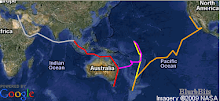
MapsAlthough our
online interactive maps have been finished for a while (they were automatic), we were a little behind on our Google Earth maps. We've gotten lots of great feedback on the value of our data and wanted to finish it for our friends (and friends of friends) heading up the Red Sea this up coming season.
We would also like to get other cruisers/adventurers to add positions to their blogs so we can build an online blog reference map. Check out the details on our
community blog submission page.
We used Google Earth offline to find better anchorages when the charts were off (Kiribati, Fiji, Indonesia and the Red sea). We've finally finished the details on our Google Earth maps and made them viewable online and down loadable for offline use.
We've finally finished the details on our Google Earth maps.
27,500 nM of GPS tracks
981 Placemarks (anchorages, day/night positions while on passage, blogs, photos, journals, videos).
We also added an online
kml viewer to view the content while online.
New Community BlogIn case you
missed the news we created a community blog, we hope you will share your favorite content and join our
facebook fan page.
Cleaned up our Astore links
Turns out we created a huge headache for ourselves by adding links of the various products we were describing on our
What Works pages to our
Amazon astore. Amazon changes product id's and links frequently so the links change
and their reporting mechanism only references internal astore items for the last month.
We've relinked 100's of items (
shown here).
We didn't create the store to make money but the little bit we do make (we get 4% at no cost to you), helps contribute to the cost of running the site. To date it has NOT even covered our hosting fees.